
![]()
Maps
Charts and Maps
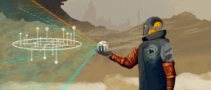
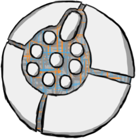
Maps in Omneutta have evolved over time, but for centuries have been produced by the enigmatic Wayfarers. Most modern maps are spherical objects covered in raised plates and buttons. These buttons open the holographic projecting capabilities of the map, while plates direct the map on where or what to display though some maps reverse these features.
Types of Maps
Related Links
- Omneutta
- Celestial Bodies
- Wayfarers
Most maps can create large-scale holographic displays when placed on compatible stands.
Star Chart
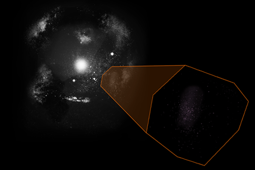
Star charts, along with the map of the Known Universe are designed to show parts of a whole. Whether they show -spaces of the Known Universe pulled from Omneutta, or Local Groups pulled from a space, these images illustrate wide swaths of space.
Projection Map

Projection maps are based on the Eckert-IV projection, which is an equal-area pseudo-cylindrical projection.
Projection maps are only used on celestial bodies that have both hospitable and inhospitable continents, where they are shown in blue and orange respectively. Named continents are also identified by text nearby.
Topographic Map
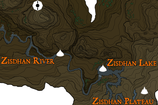
Topographic maps are based off of real-world contour maps, and are inspired by aspects of several great video game maps of years past. Read the map legend below to learn more about what’s on the maps.
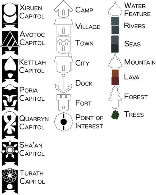
Topographic maps are used on several different type of location articles including planet-stars and star-planets, continents from celestial bodies who are too large to display at once, and continemos. All of these articles feature Geographic and Climate descriptions, which are explained to the right:
Geography
- Flatlands
- Rolling Hills, Grassland, Savanna, Woodland, Forest
- Mountainous
- Basin, Glacial
- Highlands
- Plateau, Butte
Climate
- Humid
- Rainforest
- Torrential
- Dry
- Arid
- Semi-Arid
- Binary: Stark contrasts between half of the year in warmth, half in cold
- Warm: two extended periods of average temperature, short snaps of cold and hot seasons
- Hot/Cold: Either an extremely hot or cold half of year, other half is average
- Dry/Wet: Precipitation Descriptor
- Torrential: Binary climate next to or near a Humid Torrential, and is affected by sudden precipitation
- Temperate
- Seasonal: Four seasons of nearly identical length
- Subpolar: Four seasons, with a harsh cold-season
- Subarid: Four seasons, with a harsh hot-season
- Boreal: Less than half the year above freezing
- Oceanic: Steady periods of precipitation
- Continental: Seasonal periods of precipitation
- Polar: More than 90% of the year below freezing
- Tundra: not always frozen
- Ice Cap: always frozen
- Highlands: Climate varies by altitude, only for use with Highland geography
Settlement Map
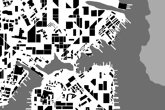
Settlement maps are based on Figure-Ground maps, which use black and white to show structures and space respectively.
Settlement maps are only used on cities, towns, and other locales that have an abundance of structures, shown in black with the space around them – whether developed streets or dirt roads are shown in white. If applicable, water is shown in dark gray and space, for settlements on the edge of continents, is shown in light gray.

